I am a PhD candidate at UCL’s SpaceTimeLab, supervised by Dr James Haworth, Dr Aldo Lipani, and Dr Stefano Cavazzi. My research is funded by UKRI (EPSRC) and Ordnance Survey (OS).
I study how people communicate about place: what they ask, how they ask it, and what this reveals about human spatial cognition at scale. I work at the intersection of GeoAI, NLP, and HCI, using query logs and conversational AI datasets to characterise spatial information needs across interfaces. I’m particularly interested in subjective spatial questions – those that go beyond what deterministic GIS can answer, and expose the gap between place as data and place as lived experience.
I am a co-founder and CTO of Safest Way, a Geovation-backed startup developing safety-focused pedestrian navigation. Read about it on BBC News, The Standard, or in The Conversation.
Publications
 COSIT 2026 (accepted)
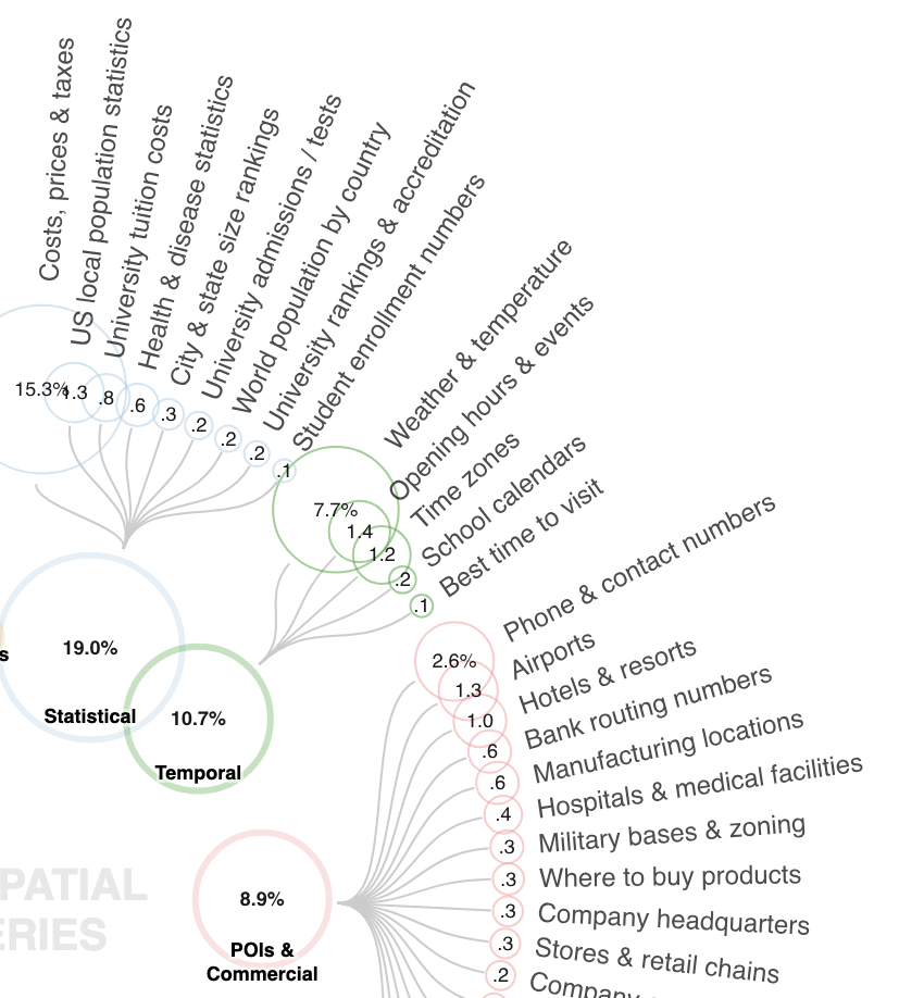
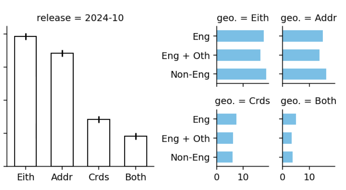
Much of Geospatial Web Search Is Beyond Traditional GIS
Ilya Ilyankou, Stefano Cavazzi, James Haworth
[People ask the web about place far more than we thought, and most of it is practical lookups (costs, hours, contact details, weather, etc.) that GIS isn't traditionally built to answer.]
 MIRAGE @ IUI 2026
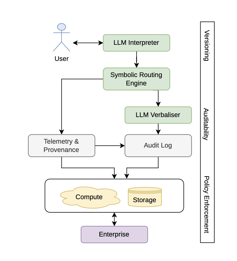
The Scenic Route to Deception: Dark Patterns and Explainability Pitfalls in Conversational Navigation
Ilya Ilyankou, Stefano Cavazzi, James Haworth
[Conversational navigation risks turning routing from a verifiable geometric task into opaque persuasion; a neuro-symbolic architecture grounding LLM outputs in pathfinding algorithms offers a path to trustworthy, explainable pedestrian navigation.]
 GISRUK 2026
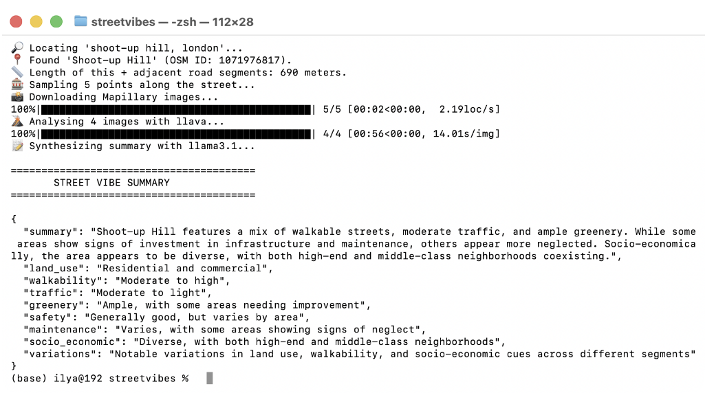
StreetVibes: An Open, Modular Pipeline for Reproducible Street-Level Urban Perception Analysis
Ilya Ilyankou, Stefano Cavazzi, James Haworth
[A privacy-preserving, open-source tool that converts street-level imagery into semantic urban indicators by orchestrating OSM, Mapillary, and local vision-language models.]
 GeoExT @ ECIR 2026
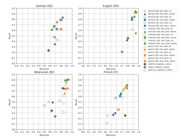
Multilingual Synthetic Corpora for Geoparsing Using Large Language Models
Ilya Ilyankou, Franz Welscher, Paddy Smith, Tatu Leppämäki
[Using LLMs to generate synthetic geoparsing corpora across four languages and regions, exposing systematic limitations in low-resource settings tied to geographic data coverage and linguistic variation.]
 Remote Sensing Applications: Society and Environment (2026)
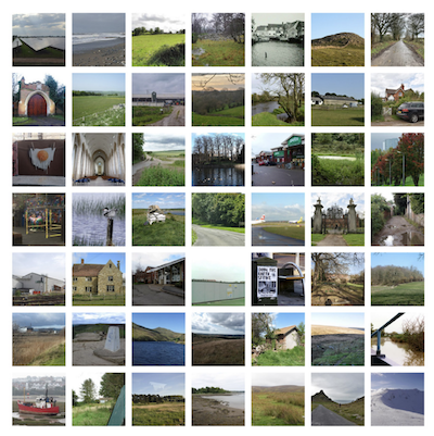
CLIP the Landscape: Automated Tagging of Crowdsourced Landscape Images
[What you see isn't always what gets tagged. A CLIP-based classifier combining image, location, and title embeddings to predict geographic context tags from landscape photos, improving spatial understanding in data-sparse regions.]
 SIGSPATIAL'25
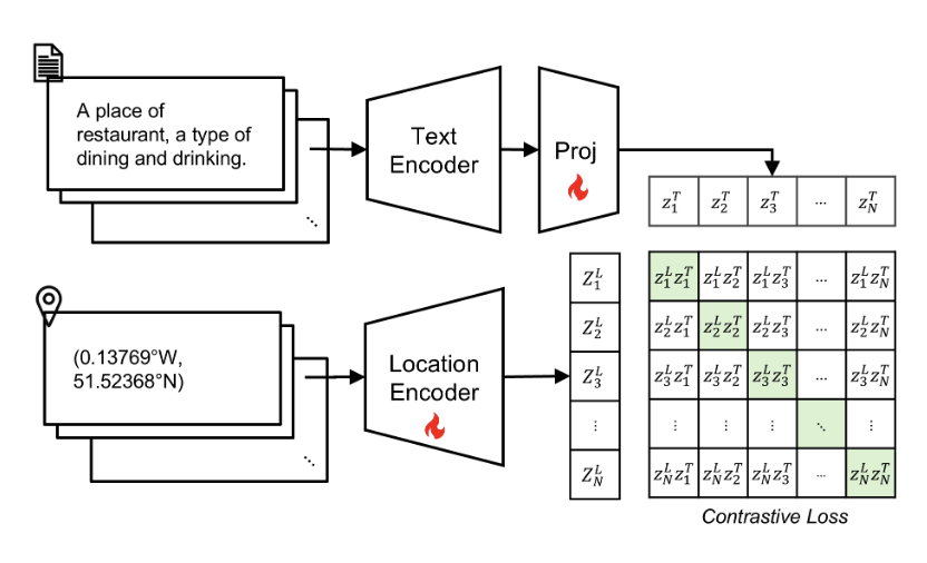
Into the Unknown: Applying Inductive Spatial-Semantic Location Embeddings for Predicting Individuals' Mobility Beyond Visited Places
[Multimodal location embeddings fusing coordinates and POI semantics via contrastive learning improve individual mobility prediction, particularly for previously unseen locations.]
 CV4DC @ ICCV'25
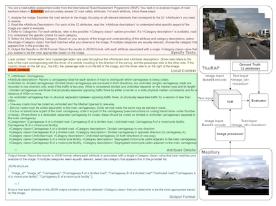
V-RoAst: Visual Road Assessment. Can VLM be a Road Safety Assessor Using the iRAP Standard?
[A zero-shot VQA framework using vision-language models to classify iRAP road safety attributes from street-level imagery, reducing the cost of infrastructure risk assessment in low-resource settings.]
 SIGSPATIAL'24
Quantifying Geospatial in the Common Crawl Corpus
Ilya Ilyankou, Meihui Wang, Stefano Cavazzi, James Haworth
[Nearly one in five Common Crawl documents contains geospatial information, offering a quantitative basis for understanding why LLMs develop spatial reasoning capabilities.]
 SIGSPATIAL'24
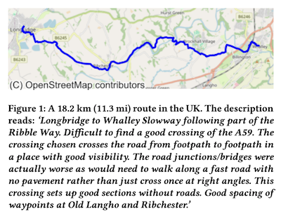
CC-GPX: Extracting High-Quality Annotated Geospatial Data from Common Crawl
Ilya Ilyankou, Meihui Wang, Stefano Cavazzi, James Haworth
[A pipeline to extract paired GPX tracks and human-written descriptions from Common Crawl, yielding a multimodal dataset of 1,416 real outdoor routes for geospatial and NLP research.]
 SuMob @ SIGSPATIAL'24
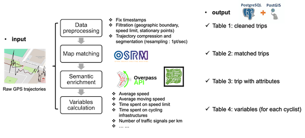
CycleTrajectory: An End-to-End Pipeline for Enriching and Analyzing GPS Trajectories to Understand Cycling Behavior and Environment
Meihui Wang, James Haworth, Ilya Ilyankou, Nicola Christie
[An end-to-end pipeline that map-matches cyclists' GPS trajectories to OpenStreetMap, enriching raw data with road semantics and derived mobility metrics.]
 GeoExT @ ECIR 2024
Do Sentence Transformers Learn Quasi-Geospatial Concepts from General Text?
[Fine-tuned sentence transformers show zero-shot capacity to match hiking queries to route descriptions, hinting at untrained geospatial utility.]
Professional experience
-
Intern (Responsible AI Team), Nokia Bell Labs (Summer 2026)
-
Intern, The Alan Turing Institute (Autumn 2025)
-
Data engineer, Geolytix (2022–2025)
-
Full-stack developer, CTData Collaborative (2018–2022)
Teaching
As a postgraduate teaching assistant at UCL (2024–25) and lab demonstrator at Birkbeck (2025–26), I have supported modules in geospatial programming, spatial analysis, and data analytics.
Education
-
PhD in Geomatic Engineering / Geospatial AI – University College London (UCL), 2023–2027
-
MSc in Geographic Information Science (Distinction) – University of Leeds, 2019–2022
-
BSc in Computer Science and Studio Arts (summa cum laude, Phi Beta Kappa) – Trinity College (Connecticut), 2014–2018
-
Worcester College, University of Oxford – Visiting student focusing on machine learning and game theory, 2016–2017
Hands-On Data Visualization
Hands-On Data Visualization: Interactive Storytelling from Spreadsheets to Code (O’Reilly), co-authored with Jack Dougherty. Available open-access in English, and translated into Korean and Traditional Chinese.
Since 2022, all royalties (currently over $5,000) have been donated to humanitarian relief efforts in Ukraine, most recently to The HALO Trust.